Unmanned Aircraft Systems (UAS)

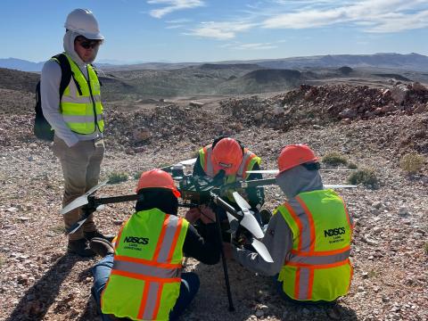
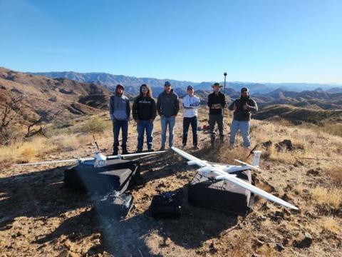
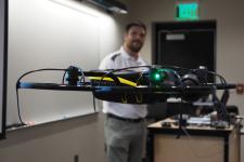
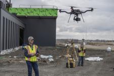
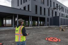
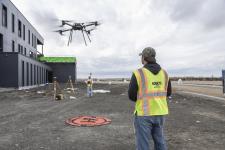
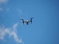
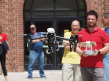
UAS technology is one of the fastest growing industries and new applications of this technology are constantly being discovered in many different industries around the world.

Apply  Visit  Request Information

Academic Options

off
UAS – Business and Marketing Emphasis (A.A.S.)

drone flying in front of teacherThe Business and Marketing emphasis area will provide students with knowledge on business and marketing practices along with communication and presentation skills.

  • Type: A.A.S. degree (Unmanned Aircraft Systems degree sub-plan)
  • Location: Wahpeton
  • Cluster: Architecture and Construction

» View Program Information & Admission Requirements

UAS – Civil Engineering Emphasis (A.A.S. degree)

Drone flying in construction zoneThe Civil Engineering Technology Emphasis will prepare students for work as civil technicians in construction related industries with the ability to utilize drone technology.

  • Type: A.A.S. degree (Unmanned Aircraft Systems degree sub-plan)
  • Location: Wahpeton
  • Cluster: Architecture and Construction

» View Program Information & Admission Requirements

UAS – Construction Inspection Emphasis (A.A.S. degree)

Drone flying in front of building under constructionThe Construction Inspection emphasis area will provide students with knowledge of construction practices, construction specifications, print reading, construction document management, material testing, and quality control practice.

  • Type: A.A.S. degree (Unmanned Aircraft Systems degree sub-plan)
  • Location: Wahpeton
  • Cluster: Architecture and Construction

» View Program Information & Admission Requirements

UAS – Land Surveying Emphasis (A.A.S. degree)

drone flying in area with land surveyorsThe Land Surveying Emphasis will prepare students for work as surveying technicians in construction related industries with the ability to utilize drone technology.

  • Type: A.A.S. degree (Unmanned Aircraft Systems degree sub-plan)
  • Location: Wahpeton
  • Cluster: Architecture and Construction

» View Program Information & Admission Requirements

UAS – Architectural Modeling Emphasis (A.A.S.)

Print readingWith the Architectural Modeling Emphasis, in addition to the UAS courses, students will take multiple modeling courses using Autodesk Revit software. Construction methods and materials and print reading courses will also be included in the program for students to have a good knowledge of construction and ability to read prints.

  • Type: A.A.S. degree (Unmanned Aircraft Systems degree sub-plan)
  • Location: Wahpeton
  • Cluster: Architecture and Construction

» View Program Information & Admission Requirements

UAS – Transfer (A.A.S. degree)

Drone flying in the blue skyThe Transfer Emphasis will provide students with a strong knowledge and skills for various applications of drone technology and compliment them with general education courses suited for transferring to a university for drone related studies.

  • Type: A.A.S. degree (Unmanned Aircraft Systems degree sub-plan)
  • Location: Wahpeton
  • Cluster: Architecture and Construction

» View Program Information & Admission Requirements

Unmanned Aircraft Systems (UAS) – Certificate
Unmanned Aircraft Systems (UAS)

The Unmanned Aircraft Systems (UAS) certificate program is designed to provide a broad understanding of the use of UAS in a commercial environment.

  • Type: Certificate
  • Locations: Wahpeton
  • Cluster: Architecture and Construction

Add this Certificate to an Associate’s Degree you are currently pursuing and you will be an important asset for your future employer as a Remote Pilot.

» View Program Information & Admission Requirements

With any of the UAS program options students will learn how to fly, collect and process data through hands-on learning in these areas:

  • Photogrammetry
  • Thermography
  • Multi-spectral Imaging
  • LiDAR
  • Photography
  • Videography

Students will also learn how to process 3D models, 3D surfaces, calculate surface volumes, analyze thermal images, analyze vegetation with NDVI mapping, use LiDAR data, edit photos and create video productions using:

  • Pix4D Imaging Software
  • ESRI ArcGIS
  • Autodesk Civil 3D
  • Autodesk Recap
  • Autodesk Infraworks
  • Adobe Lightroom
  • Adobe Photoshop
  • Adobe Premiere Pro
  • Adobe After Effects
Unmanned Aircraft Systems Graduates from 2023-2024 Academic Year
Graduates Registered Avg. Beginning Annual Salary Reported High Annual Salary Placement Rate
8 $104000 100%

Learning drones at NDSCS expands above the classroom

Six students stand around two large drones on the ground. The setting is the desert landscape of Arizona.
12-30-2024

Article published by John Anderson at Wahpeton Daily News on December 28, 2024.


For years, Seth Simonson has made headlines for his innovative use of GPS systems and drones. 

It started with approval in 2016 from the North Dakota State College of Science (NDSCS) for Land Surveying Program Coordinator Jeff Jelinek and Simonson to look into drones when new FAA regulations for commercial operations of drones came out. 

By 2017, Simonson, working with students, came up with a groundbreaking concept, as they flew drones and used GPS to locate graves of veterans in Richland and Wilkin counties. 

Today, Simonson, the Associate Professor/Program Lead of the Land Surveying and Civil Engineering Technology/Unmanned Aircraft Systems at North Dakota State College of Science has expanded learning past the classrooms in Wahpeton. 

Students travel to Arizona and work with other colleges through the Center to Advance the Science of Exploration to Reclamation in Mining. 

They are working on an incredible 20,000 acre mining project that will take three more years to complete. The best of the best are working in Arizona on this project. 

For Braden Heuer of Mooreton, a Wyndmere High School graduate, taking the courses at NDSCS and going to Wickenburg, AZ., was not only an incredible experience, but he is looking into a new career field. 

Heuer also took an interest in drones as soon as regulations changed. He flew one during a Wyndmere Football game to make a promotional video for the school. The police came and said he could not fly over people. 

He was able to show the police what he was recording and that he was not flying over people and he was allowed to keep recording. 

This may not be Heuer’s last interaction with police. He might be working with them someday. “Thermal drones are an important tool for finding drug dealers,” Heuer said. 

When asked what benefits there are to drones, he said he didn’t know where to start. “There are benefits in real estate, photography, which I do myself, there is light detection and ranging,” he explained. “There is a sensor on the bottom of a drone, you attach a module that spins, it shoots these lasers that scan an entire area efficiently.” 

And he’s learning in and out of the classroom. “You can use drones to find vegetation, farmers use them to detect weeds in the crops,” Heuer said. “They just came out with new technology where you can fly three feet from the ground and you can detect things 10 feet under. I just learned this three weeks ago.” 

And with drones comes responsibilities. “You have to be a good pilot, you need to know the laws and you have to take (a class and pass a UAG test) to be licensed,” he said. “You need to know airspaces ... it’s a handful of work.” 

Simonson knows about that work all too well. 

Simonson’s start 

When Jelinek and Simonson received approval from their industry advisory committee, they wanted to add drone technology “as a new tool in the Land Surveyors toolbox,” Simonson explains. “That turned into a class in 2017 and a one-year certificate program in 2018, and now we have a 2-year AAS degree in Unmanned Aircraft Systems (UAS) which began last year in the Fall of 2023,” Simonson said. 

In just four years, the NDSCS program was recognized. “I was approached in late 2021 by a representative for the National Center for Autonomous Technology (NCAT) about being a part of an NSF (National Science Foundation) grant funding,” Simonson said. “The funding would lead the exploration of the use of drones to map surface mineralogy with hyperspectral cameras together with the Center to Advance the Science of Exploration to Reclamation in Mining (CASERM) at the Colorado School of Mines in Golden, CO.” 

Racing to Arizona 

Drones are technically called UAS, or Unmanned Aircraft Systems. And those drones were the reason this project started in 2023. “In March 2023, I took eight NDSCS students for two weeks (one week, they were north of Phoenix and one week, southwest of Las Vegas) to work on the application of a Hyspex hyperspectral sensor on a heavy lift drone,” Simonson said. “From this, we have branched off on other projects with CASERM and the Colorado School of Mines like this project we took in November to Wickenburg, AZ.”

The most recent trip was a success. “The project went well and we were able to map approximately 3,300 acres of land creating a high resolution image and surface model of the area, Simonson explained. “Students did well and worked long days and hiked lots of miles up and down mountainsides to get the data. Students learned how difficult it is to work and collect data in areas that are a little more vertical than what they are used to around here.” 

Heuer said the goal of his team was “to map out our section of 20,000 acres of land for mining to see if there is copper there. Geologists came out to check on hot spots.“ 

Typical day 

Heuer said his day was different from others. Each group had a different emphasis on the drone program. 

“Three of us were land surveying. We shot points to get better horizontal and vertical precisions,” Heuer said. “We had to get it down to super-accurate precision. We made a huge orthomosaic image of the entire area, all 20,000 acres — at least we tried to! Out of 12,000 photos we took, we stitched them into one massive image. It took two weeks to process all of it.” 

The mining company that owns the land put Heuer’s team in the best place to start, he said. 

“I learned quite a bit. Besides the rapid temperature changes, the terrain was completely different. I did not expect it to be so hilly,” he said. “Two of us were hiking up an almost vertical cliff of rock to set up the (drone cameras). There were a lot of equipment issues to overcome before we could fly zones.” 

Heuer said one thing he learned was “how to find section corners and the original plats. We were told ‘they were over a bridge.’ But they were not. I had to reference them off a controller, then we would hike and shoot a certain point. It took a good hour, hour-and-a-half to shoot it and walk back.” 

The trip is also a big part of his final graduation project. “The section corners are also for a capstone project we are doing,” Heuer explained. “When we shot them with a GPS I had at the end of a stick, it told us in the software exactly where that would be in a photo. 

Why is it so important to be accurate? “Your data has to be right,” Heuer said. “That’s how you do your job well with drones. Drone jobs are so precise these days.” 

And then there was the weather. Arizona seems like a shorts and t-shirt state, but it is not. “The weather was interesting. It got hot, then it got extremely cold quickly,” Heuer said. “I was definitely not ready for it, I did not have a coat. We thought the mornings would be in the 50’s, but it was in the 20’s. I remember waking up at 7 a.m. and gassing up our Ranger as it was so cold, about 20 degrees!” 

The students returned knowing more about each other, new parts of the country and expanded their knowledge from the classroom into real-world use. 

As a result, more students will benefit from this. “It will probably be closer to a three-year project as we may go twice in 2025 (once in April and again in November),” Simonson explained. “We have a total of approximately 20,000 acres to map, but now that we have permanent survey control monumentation on the site which we set for this trip, we should be able to map more area in our week trips there.” 

The trip has also built personal and professional relationships. 

“We also intend to go back to the original hyperspectral project and collect some data in April 2025 while working on this mapping project,” Simonson said. “We have enjoyed working with the Colorado School of Mines students and faculty and they have enjoyed working with us so I am sure this will be a relationship that will continue many years to come.” 

Future heights 

Heuer is taking land surveying and civil engineering classes at North Dakota State College of Science. 

However, taking the main UAS class with Simonson has opened up new doors. As a freshman, Simonson was impressed that Heuer started flying drones at age 12 and already knew how to fly a Mavic 2 Pro Drone. 

The class was learning the basics on a Mavic 3 Pro Drone, but the two had the same software. Heuer was already ahead of the class. Which will once again get him to the top of the class as his higher-education continues thanks to NDSCS. 

“It was so much fun,” Heuer said. “Now, I am in my second year. I am thinking of transferring to USD for drones or NDSU.”


NDSCS Unmanned Aircraft Systems students participate in an NSF-funded research project

Land Surveying students at work on drone
04-04-2023

North Dakota State College of Science (NDSCS) recently collaborated with the National Center for Autonomous Technologies (NCAT) and the Colorado School of Mines to provide a group of seven students from NDSCS’s Unmanned Aircraft Systems certificate program with a unique 16-day fieldwork experience. The students traveled to Arizona and Nevada in March, where they used drones to collect data from mining sites using hyperspectral imaging, a technology that captures data from across the electromagnetic spectrum beyond the visible light our eyes can see.

The trip was funded by a National Science Foundation (NSF) grant secured by NCAT, whose mission is to educate technicians for careers in autonomous technology fields. The grant covered all travel expenses for the students and provided them with a stipend for their work.

NDSCS students were responsible for planning missions, flying drones, and collecting data. Seth Simonson, NDSCS associate professor, accompanied the students and led curriculum development for the UAS component of the project. Graduate students from the Colorado School of Mines evaluated the data collected to identify and quantify material in the mines. The group from NDSCS spent eight days outside of Phoenix, Ariz., and eight days in Henderson, Nev. traveling approximately 60 miles southwest from there into California, to complete their fieldwork. The primary drone used for the project was a $70,000 quad drone equipped with a $300,000 camera that collects 490 wavelength bands. This was the NDSCS students’ first time using a camera with this level of spectral range. “Getting flight time with this high-performance camera was an incredible learning experience for the students,” said Simonson. “It sparked a lot of interest in the future of the industry.”

The NDSCS students who participated in the study included:

  • Tyler Cunningham, Land Surveying and Civil Engineering Technology, Thompson, N.D.
  • Annah Evavold, Architectural Modeling and Design Technology, Battle Lake, Minn.
  • Bailey Goschke, Land Surveying and Civil Engineering Technology, Oslo, Minn.
  • Mark Jenniges, Land Surveying and Civil Engineering Technology, Brooten, Minn.
  • Joel Kavaloski, Land Surveying and Civil Engineering Technology, Lindstrom, Minn.
  • Noah Cunningham, Land Surveying and Civil Engineering Technology, Minot, N.D.
  • Trenton Thomasson, Land Surveying and Civil Engineering Technology, Fargo, N.D.

In addition to working with advanced technology, the students valued working in different terrain. “Around here, it’s all flat land. Out there, it’s desert and mountains,” said Mark Jenniges. “You had to pick out your vantage points. You had to figure out how you were going to plan your missions so that you didn’t wreck or lose sight of your drone because you always have to have a visual line of sight. You had to pick out take-off and landing spots–it was all very valuable experience.”

The trip also allowed students to collaborate with other professionals. “We were in the field doing a job,” said Annah Evavold. “It was our job to collect the data so the researchers could do their part in the project. We had to know what we were doing and we took it seriously.”

Joel Kavaloski said he enjoyed working with the graduate students. “The geologists explained the science behind why we were capturing the data. We knew where the drones could fly, but we didn’t necessarily know their points of interest. They helped us understand the bigger picture.”

“Overall, it was just a great work experience for us,” said Tyler Cunningham. “If future employers see that on a resume, I think they’ll take into consideration the time we spent planning missions and developing flying skills.”

This collaboration between NDSCS, the Colorado School of Mines, and NCAT demonstrates the importance of partnerships and the potential for groundbreaking research when institutions come together. Simonson looks forward to future runs of the study where he will continue to lead the UAS curriculum.

The success of this project also demonstrates how UAS is one of the fastest-growing industries with new applications constantly being identified. In response to emerging careers in unmanned aerial technologies, NDSCS is expanding its UAS certificate program into a standalone associate degree. Starting in the fall of 2023, NDSCS will offer an Associate in Applied Science degree in Unmanned Aircraft Systems with six emphasis areas including Land Surveying, Civil Engineering Technology, Architectural Modeling, Construction Inspection, Business & Marketing, and Transfer. Through a hands-on curriculum, students will learn about unmanned aircraft types, legal operational guidelines, preflight planning, piloting UAS, and collecting and processing data through photogrammetry, thermography, multispectral imaging, LiDAR, photography, and videography. Students also earn a Federal Aviation Administration (FAA) Remote Pilot Certificate preparing them to become remote pilots in different commercial environments and industries. Simonson said the FAA supports NDSCS’s expanded curriculum because of its industry focus and hands-on approach. “Students use UAS to collect and process data just as they would in industry, which distinguishes our program.”

Additional information about the NDSCS Unmanned Aircraft Systems program can be found online at NDSCS.edu/UAS.

Article written by NDSCS and submitted to external news outlets.